andcurrenton
your
boat. It also
simplifies navigation.
To use
the
plotter
in this
manner,
first
recall
awaypointorstarta
route.
(See
the
Waypoint
Recall sec-
tion for more
information.)
Then
press
the PLOT
key.
A screen
similar to the one at
right ap-
pears.
PLOTTER
MENU
-
PAGE 1
CLEAR PLOT
To
clear or erase the solid track
menu selection. The
plotterwill
continue to draw
your
track af-
ter this
key
is
pressed, starting
from
your present position.
SET RANGE
Use this menu to
change
the
plotter's range
or distance
across the
plotter's display.
The
range
is 1 statute milewhen the
____
S 2M1
next to the "SAVE" label.
Use the
keys
on both sides of
thescreen to enterthe
waypoint
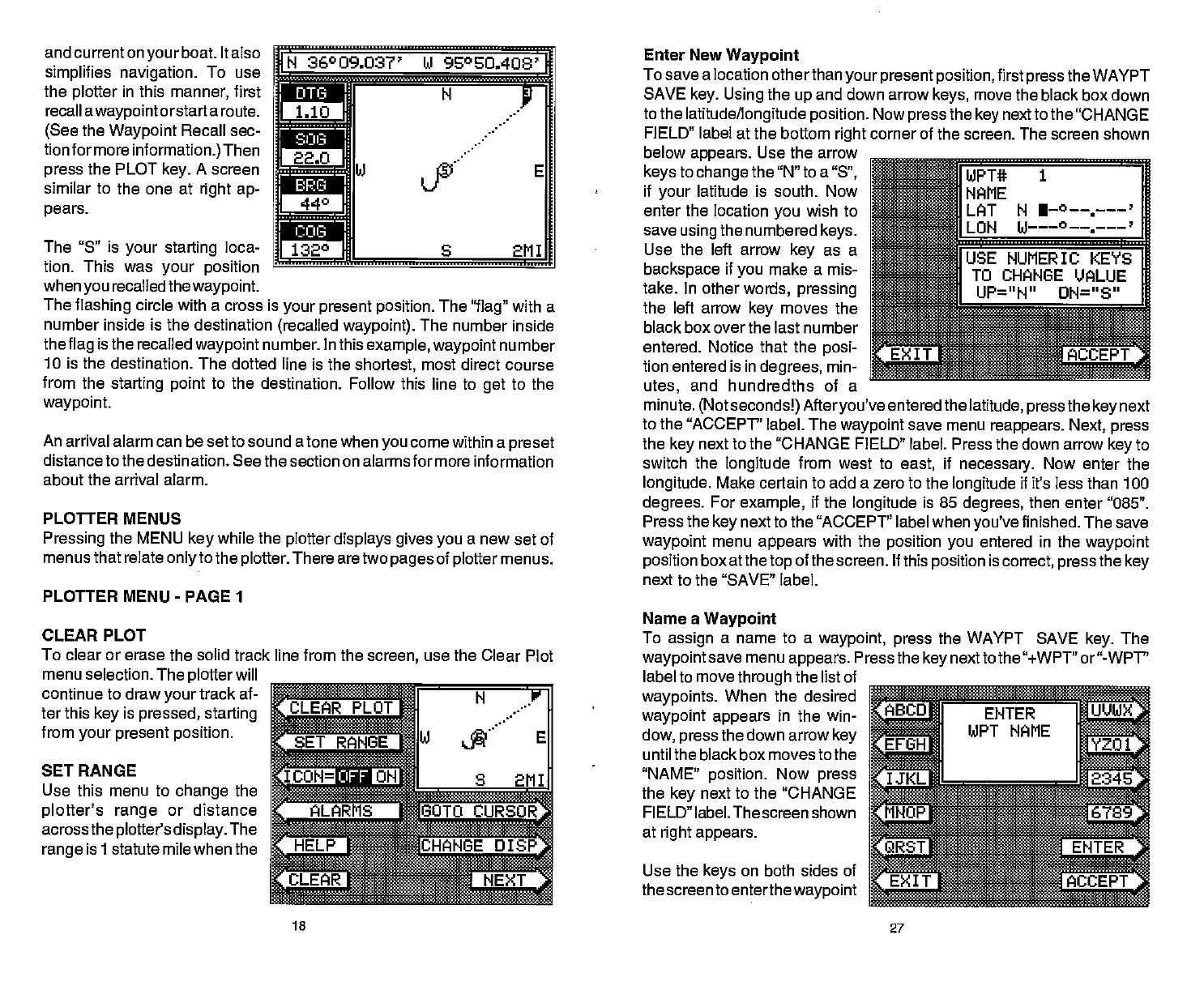
N
36°09.037' U 95%0408'
N
1
L
J
DTEi
jul
fl:
a.
r
fl:
'bpij —l.
r'706 -:1
f
E
Enter New
Waypoint
To save a location
otherthan
your present position,
first
press
the WAYPT
SAVE
key.
Using
the
up
and down arrow
keys,
move the black box down
to the
latitude/longitude position.
Now
press
the
key
next to the "CHANGE
FIELD" label
at the bottom
right
corner of the screen. The screen shown
SuIiRF
NAME
LET N I—°--—.———'
1LON
below
appears.
Use the arrow
keys
to
change
the "N" to a
"Sn,
if
your
latitude is south.
Now
enter the location
you
wish to
save
using
the numbered
keys.
Use the left arrow
key
as a
backspace
if
you
make a mis-
take. In other
words,
pressing
the left arrow
key
moves the
black box over the last number
entered. Notice
that the
posi-
tion
entered
is
in
degrees,
min-
utes,
and hundredths of a
The "5" is
your starting
loca-
tion. This was
your position
when
you
recalled the
waypoint.
The
flashing
circle with a cross is
your present position.
The
"flag"
with a
number inside is the destination
(recalled waypoint).
The number inside
the
flag
is the recalled
waypoint
number. In this
example, waypoint
number
10 is the
destination. The dotted line is the
shortest,
most direct course
from the
starting point
to the destination. Follow this line to
get
to the
waypoint.
An
arrival alarm can be set to sound a tone when
you
come within a
preset
distance to the destination.
See the section on alarms for more information
about the arrival alarm.
PLOTTER MENUS
Pressing
the MENU
key
while the
plotter
displays gives you
a new set of
menus
that relate
onlyto
the
plotter.
There are two
pages
of
plotter
menus.
line from the
screen,
use the Clear Plot
LJSE
NUMERIC KEYS
_____
TO CHANGE
VALUE
UP=" N" ON=" 8"
minute.
(Not seconds!) Afteryou've
entered
the
latitude, press
the
key
next
to the "ACCEPT' label. The
waypoint
save menu
reappears.
Next,
press
the
key
next to the "CHANGE FIELD" label. Press the down
arrow
key
to
switch the
longitude
from west to
east,
if
necessary.
Now
enter the
longitude.
Make certain to add a zero
to the
longitude
if it's less than 100
degrees.
For
example,
if the
longitude
is 85
degrees,
then
enter "085".
Press the
key
next to the "ACCEPT" label when
you've
finished.
The save
waypoint
menu
appears
with the
position you
entered in the
waypoint
position
box atthe
top
of the screen. If this
position
is
correct, press
the
key
PLOT
N.Y
ICON=jIiJ
S 2MI
—
LARNS GOTO
CURSOR.
Name a
Waypoint
To
assign
a name to a
waypoint, press
the WAYPT SAVE
key.
The
waypoint
save menu
appears.
Press the
key
next to the "+WPT" or"-WPT"
label to move
through
the list of
waypoints.
When the desired
waypoint appears
in the win-
dow,
press
the down arrow
key
until the black box moves to the
"NAME'
position.
Now
press
the
key
next
to
the
"CHANGE
FIELD" label. The screen shown
at
right appears.
UANGEOISP
15
27
PDF compression, OCR, web-optimization with CVISION's PdfCompressor